92 Main St, Ashland, ME 04732 Phone: (207) 435-6213 Contact Us

Experience the Tradition of the North Maine Woods!

Experience the Tradition of the North Maine Woods!

Experience the Tradition of the North Maine Woods!

Experience the Tradition of the North Maine Woods!

Please take a moment to view our online brochure/book!

Our online brochure is also available here in pdf format!
(File Size Approximately 55MB)

Welcome to North Maine Woods

NMW is one of Maine's most unique regions which provides remote recreational opportunities and supports our natural resource based economy. In this magazine, you'll find tips for a safe trip and learn more about forest resource management.

Welcome to the North Maine Woods - Multiple Ownership - Multiple Use Management Area. The private forest landowners and state governmental agencies cooperating in this program are pleased you have chosen to visit our web site. It is designed to help you have a safe and pleasant trip in the area, plus provide you with valuable information on forest resource management and recreational use.

The area provides numerous outdoor recreational opportunities for over 100,000 visitors each year while at the same time providing renewable forest resources which are a major part of Maine's economy. Harvesting wood products and providing recreation are compatible if managed properly. Providing proper management of day use and camping is the main goal of the North Maine Woods organization.

Regarding the Solar Eclipse, April 8th, 2024.


Unfortunately, our operating season does not begin until early May. We are asking visitors to avoid attempting to access the campsites at the time of the eclipse. The entire North Maine Woods region is privately owned and attempting to access the area this early in the spring is not advised due to extremely wet conditions that can cause tremendous damage to the road systems as well as a host of other hazards that could potentially occur. Many of our sites are very remote, with no cell service in any direction, making it extremely difficult should visitors breakdown, become stuck or need EMS services. In addition, none of the campsites or access roads to the campsites are plowed or maintained during the winter months, thus making it very difficult to access the sites (due to snow and/or mud) without causing immense damage to those roads and sites as well.


Thank you. 

ARE YOU LOOKING FOR A JOB?

Road Construction, Closures & Updates:

The following roads are expected to be plowed until harvest contracts are filled:

(NOTE:  Green/bold information has been confirmed)

Golden Road to Telos to Chamberlain Bridge (KFM)

Golden Road to St. Zacherie border crossing

Chamberlain Bridge to Pinkham Road junction (KFM)

Pinkham Road from 522 Road to Ashland  (7I)

Chamberlain Bridge to Grand Chermain Road  (KFM)

Grand Chermain Road to Narrow Pond Road (7I)

490 Road by 5th St. John to Baker Lake Road To be maintained until mid January

Poulin Road from Thoroughfare Brook to Realty Road (Landvest) Open after Jan. 1st

St. Juste Connector from St. Juste Road to Realty Road (7I)

Cyr Road from Poulin Road to St. Juste Road (Landvest) Open after Jan. 1st

From 522 Road over Johns Bridge to Thoroughfare Brook (7I)

Indian Pond Road towards Lock Dam/Eagle Lake ??

Rocky Brook Road from Portage to the St. Francis connection and intersection with the Blanchette Rd. by Musquacook Stream. (Irving)

Robinson Road from St. Pamphile to Estcourt/Irving Road (7I)

Estcourt Road mile 10-32 (Landvest)

Realty Road from 6 Mile to Musquacook

Musquacook corner past Clayton Lake towards St. John River (Landvest)

St. Pamphile to St. John River Bridge (Blanchet)

St. John River Bridge to Musquacook Stream & T12 R10

Clayton Lake to St. Pamphile via 17 Mile and Boulevard Road. (Landvest)

From Realty Road by 2nd Musquacook to Blanchette Road (Landvest) Open to pickup traffic

St. Francis Road from St. Francis to the Rocky Brook Road (Irving)

Jack Mountain Road to Island Pond Road (7I)

Island Pond Road to Smith Brook Road (7I)

Smith Brook Road to Pell & Pell Road (7I)

522 Road to Connecter Road from the Pell& Pell  Road end. (7I)

Pell& Pell Road to 522 Road will be plowed (7I)

Depot Lake road from St. Pamphile to Daaquam Road  – Huber/TNC Mile 22.5 south to border

Carter Road/Little Brailey Road –  TNC Open to pickup traffic up to mile 9

Brailey Brook Road from St. Aurelie Road to intersection of 490 Rd (Tree Star)

St. Aurelie Rd (border) to St Juste/Edmond Roy intersection (Tree Star)

Baker Lake Road miles 24-27. (Landvest)

St. Francis Lake Road (Landvest)

Blackstone Road (Irving)

Beaver Brook Road (7I)

St. Croix Road (Irving)

From our contacts we understand the following roads are not plowed:

McClusky Brook Road from Thoroughfare Brook to Churchill Dam. (Landvest)

Oxbow Road from Oxbow to Pinkham Road

Ragmuff Road by Caucomgomoc to St. Juste

Craigville Road to Pinkham Road (Daaquam Lumber)

Chase Brook Road from Pinkham to Jack Mountain

522 Road north From Pell & Pell Road junction to Churchill Dam

Crossover road between Pinkham Road and 522 Road

From Blanchette/St. Pamphile Road north across Big Black River to junction of Robinson Road

Island Pond Road to Pell & Pell only plowed until the first of year

Hewes Brook Road from Rocky Brook Road to St. Francis

The Inn Road from Allagash to Schedule Brook

Duck Pond Road

Grand Lake Road

Camp Violette Road

Driving Safely on Privately Owned Forest Roads

All roads within the North Maine Woods are privately built and owned primarily for the purpose of managing and moving forest products.
The private landowners are willing to share their roads with members of the general public in order to visit the region’s many lakes and ponds and other natural resources.   

ALL LOGGING TRUCKS AND OTHER COMMERCIAL VEHICLES
HAVE THE RIGHT OF WAY.  PLEASE PULL OVER WHEN MEETING THESE VEHICLES.

  • Travel with extreme caution on all logging roads.   
  • Travel at posted speeds but no more than 45 miles per hour.
  • Use a MURS radio to monitor and call out mile markers to on-coming truck traffic
  • Keep to the right when approaching a corner or cresting a hill.
  • When approaching active equipment near the roadside wait for acknowledgement from equipment operators before proceeding to pass.

Thank you!!!


Maine Moose & Winter Ticks

(Click on link below for information and current status of Maine’s moose population)
https://www.maine.gov/ifw/fish-wildlife/wildlife/species-information/mammals/moose-winter-ticks.html

GPS-enabled Dog Tracking Systems are Creating a Safety Concern for Landowners.  Corrective Action is Required for these Devices to be Allowed Use Within the NMW Region.

If you are using a GPS-enabled dog tracking device such as the Garmin Astro or Garmin Alpha tracking system, be advised that the collars for these systems operate on the same MURS (Multi-Use Radio Service) frequencies used by logging trucks for monitoring road traffic.  These collars create audible interference on truck radios that are within range of a collar operating on the same MURS frequency (i.e. channel).  The 5 frequencies used by the MURS radio and Garmin systems are:

MURS Channel 1 = 151.820 Mhz / MURS Channel 2 = 151.880 Mhz / MURS Channel 3 = 151.940 Mhz

MURS Channel 4 = 154.570 Mhz / MURS Channel 5 = 154.600 Mhz

The first four frequencies (channels 1-4) are used primarily for monitoring road traffic with each road system in the NMW region being assigned a specific MURS channel (see back for road channel list).  MURS Channel 5 has been designated as an acceptable channel for dog collars to operate on.

It is important that you make sure your dog(s) collars are operating on MURS channel 5, and by no means should a collar be operating on a channel used by the road system you are hunting or traveling on.  To check what channel your dog’s collar has been programmed to operate on, you will need to check the channel number (Alpha system) or Dog ID (Astro system) assigned to the collar by using the following information:

ALPHA SYSTEM:  The first number of the Alpha channel (followed by a Dash Number) indicates which MURS channel the dog collar is using.  For example:  3-29 indicates MURS channel 3 is being utilized, 1-18 indicates MURS channel 1, 2-7 is channel 2, etc.  Therefore anyone using the Alpha system should have a 5 as the first number for that collar.

ASTRO SYSTEM:  The Astro system assigns an ID number (0-49) as opposed to using a channel number like the Alpha system, but the MURS frequency can be determined from the ID number by using the following chart:

Dog ID Number 0-9 (151.820 Mhz)       =   MURS Channel 1
Dog ID Number 10-19 (151.880 Mhz)   =   MURS Channel 2
Dog ID Number 20-29 (151.940 Mhz)   =   MURS Channel 3
Dog ID Number 30-39 (154.570 Mhz)   =   MURS Channel 4
Dog ID Number 40-49 (154.600 Mhz)   =   MURS Channel 5

Collars that are not operating on the proper channel will need to be manually assigned to channel 5 (Alpha) or a Dog ID Number from 40 to 

49 (Astro).  Please consult your owner’s manual on how to do this manually or contact the NMW office (435-6213) for assistance. 

How to change Dog ID on Garmin Alpha tracking collars

Garmin Alpha Interface

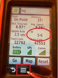
Turn on both collar and handheld. Collar must be paired with handheld to change ID

Select “Dog List”
Select dog/collar in question
Select “Show Info”
On this screen one of the boxes will say ID and have a number like 2-3, 1-25, etc. If the collar does not have an ID starting with 5-…, then it needs to be changed. Garmin collars transmit on MURS channels so 1-4 correspond to MURS channels 1-4 used for communication and safety on logging roads.
Select the 3 bars at bottom menu on the screen.

Select “Change ID”
Scroll to a 5-… number and select. Keep in mind to not choose same ID as hunting partners or other dogs in hunting party, there are about 20 options under the 5 codes.
When ID is changed unit will say “Dog (or dog name) collar is set”, press OK
Your tracking collar is now set to a frequency that will not interfere with communication used by truck drivers for road safety.

Need Some Information From Us? Fill Out Our Form!

Please enable JavaScript in your browser to complete this form.

Check out the surrounding area weather before your trip!